Just to reassure you …
While I driving near the Mississippi River near downtown Saint Louis a few days ago, I spotted this sign. Perhaps it was meant to reassure people who were nervous about seeing locomotives operating themselves . . .
Tilt shift videos, anyone?
I'd never heard of tilt-shift videos before today. It's a rather dramatic effect--using a special lens and adjusting the frames-per-second, you can make real-world large object look miniature. Here are several eye-popping examples. I kept thinking that I was looking at miniatures until I saw such realistic people enter the frame.
Photo on a wing
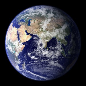
Our precious thin atmosphere
Click on this link to see a beautiful photo of the Earth by the Goddard Space Flight Center. What is stunning to me is the thin-ness of the Earth's precious atmosphere. Click on the image for a much-enlarged version.
 How was this photo taken?
This spectacular “blue marble” image is the most detailed true-color image of the entire Earth to date. Using a collection of satellite-based observations, scientists and visualizers stitched together months of observations of the land surface, oceans, sea ice, and clouds into a seamless, true-color mosaic of every square kilometer (.386 square mile) of our planet. These images are freely available to educators, scientists, museums, and the public. This record includes preview images and links to full resolution versions up to 21,600 pixels across. Much of the information contained in this image came from a single remote-sensing device-NASA’s Moderate Resolution Imaging Spectroradiometer, or MODIS. Flying over 700 km above the Earth onboard the Terra satellite, MODIS provides an integrated tool for observing a variety of terrestrial, oceanic, and atmospheric features of the Earth. The land and coastal ocean portions of these images are based on surface observations collected from June through September 2001 and combined, or composited, every eight days to compensate for clouds that might block the sensor’s view of the surface on any single day. Two different types of ocean data were used in these images: shallow water true color data, and global ocean color (or chlorophyll) data.


